Book a Club campsite
Explore hundreds of Club campsites and plan for stays throughout the year. There are plenty of locations to choose from, search and book today.
Book nowJonathan Manning explores the fringes of Northumberland National Park on this testing ride through a stunning landscape
The Northumberland hills combine a magical sense of remoteness without ever leaving civilisation far behind. This rolling route through fields and moorland from River moorland from River Breamish Club Campsite passes blink-and- you’ll-miss-them hamlets of rugged stone houses, comforting reminders that this is not a lost world, even if there’s no one about.
As the altitude rises, grazing pastures give way to heather and gorse, while streams and burns sparkle or surge depending on recent rainfall. Skirting the perimeter of Northumberland National Park, the route highlights how boundaries are manmade rather than natural. The landscape is every bit as beautiful as inside the park.
These spectacular views are hard won, though, through a series of thigh-burning climbs. At the highest points there are panoramas across to the Cheviots in the north and the Simonside Hills to the south. No wonder the area is peppered with ancient hillforts.
With precious little traffic, these are some of the quietest roads to ride in the country, the peace broken only by the bleat of lambs and call of curlews. Acrobatic lapwings wheel and dive over wetter ground, while the occasional buzzard drifts by. If luck is on your side, you may even spot red squirrels, native to the area.
In spring, crops of retina-challenging rape perform a dazzling impression of the Tour de France’s fields of sunflowers, and in late summer a purple tide will sweep across the heather on higher ground. Rest assured, at any time of year this is a sublime ride.
You can download this route from our dedicated Strava page here.

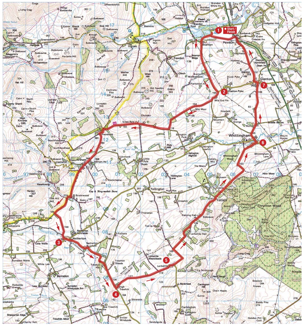
1. From River Breamish Club Campsite turn right to Branton. In Branton, turn left, signposted to Glanton and Pennine Cycleway 68. Continue on this long climb to a T-junction.
2. 3.35km – Turn right at the junction, signposted to Netherton. Follow this road as it makes 90º bends to the right and left to a T-junction in Netherton.
3. 15km – Turn left at the junction and stay on this road, initially with a burn to the right, before a long ascent. Look out for a left turn at the top of the hill after a farmhouse.
4. 18.5km – Turn left, signposted to Whittingham, Callaly and Lorbottle. Take care, this road is in poor condition. Continue to a Give Way sign.
5. 21.4km – Turn left to Whittingham and Callaly. Stay on this road all the way to Whittingham to reach a T-junction.
6. 28.8km – Turn left at the junction, signposted to Glanton. Continue to a T-junction in Glanton.
7. 31.6km – Turn left at the junction, pass The Queen’s Head on the left, and stay on the road as it climbs to the right. Continue to a T-junction in Powburn.
8. 33.7km – Turn left in Powburn, opposite The Plough Inn (not currently trading), and follow the A697 over a bridge. Take the first left after the bridge (opposite Breamish Valley War Memorial) on a single-track road. Continue to a T-junction then turn right, signposted to Powburn, to reach the Club site on the left.