Cycle route from Min Y Don
A hilly ride which passes Harlech Castle and the picturesque Llyn Cwm Bychan lake as it makes its way through Snowdonia National Park on blissfully quiet roads from Min Y Don site.
Up until April 2020 Ffordd Pen Llech, a street in Harlech, held the record for being the steepest in the world. A gradient of 37.45% saw it take the crown from Baldwin Street in Dunedin, New Zealand, for nine months before it had to hand it back when the rules were tweaked.
This route sensibly avoids such a brutal climb and settles instead for an ‘easy’ one-in-four ascent almost from the start. Harlech, it seems, is a town that does not want cyclists to leave although there are reasons beyond just gravity keeping riders here, including the lovely coastal setting, magnificent castle and immaculately maintained Min Y Don Affiliated Site.
The rewards for the muscle-burning beginning to the ride are spectacular views, starting with the seascape that opens up as the town disappears, and followed by a wonderful ridgeline as the road turns skywards again for the climb into the Rhinogydd mountains in Snowdonia National Park.
This is a big dipper of a route – giant ascents followed by white-knuckle descents as your fingers grip tightly on the brake levers. It is not just the effort of battling gravity that will take your breath away though. The scenery is spellbinding with panoramas over gnarled mountain tops, velvet-flanked hillsides and shallow rivers that race below a canopy of ancient woodland.
The highlight is undoubtedly Llyn Cwm Bychan, a lake high in the hills backed by rocky peaks. The lake marks the halfway point and provides the perfect spot for a picnic.
Avoid over-indulging though as the return starts with another out-of-the- saddle effort. The good news is that it’s quiet, with only sheep, cattle, rooks and buzzards to break the peace.
Returning to Harlech there’s a fabulous bird’s eye view of the campsite before a spine-tingling descent into town. This is not a route to take on when the weather is wet and roads are slippery but on a dry day there are views here to rival any in Britain. So check your brakes, recharge your e-bike batteries and enjoy with caution!
You can download this route from our dedicated Strava page here.
Directions

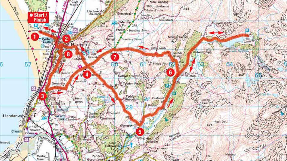
1 From Min Y Don campsite turn the right. left towards Harlech. At the T-junction turn right, crossing the railway line, then take the first road on the left with the warning sign ‘25%’. Climb the hill, called Twtil, to reach a crossroads with a shop on the left and Snowdonia Soap opposite.
2 1km – Turn right at the junction and continue for 250m before turning left, signposted to Parking and Bron Y Craig. Stay on this road and when you meet bollards turn left. Sensational sea views open to the right. Continue for 1.3km looking out for a turn on the left.
3 2.7km – Turn left, signposted to Cwm Bychan, climbing the long hill for 1.8km to reach a crossroads.
4 4.6km – Turn right at the crossroads, signposted to Cwm Bychan. The road descends all the way to a T-junction.
5 7.5km – Turn left at the T-junction, signposted to Cwm Bychan, eventually joining a river on the right. Stay on this road as it twists and turns, eventually rising to meet the lake of Cwm Bychan on the right After stopping to admire the views, retrace your tyre tracks back down into the woodland, looking out for a turn on the right.
6 15.7km – Turn right by the ‘no lorries’ sign, and climb the steep, narrow road, passing through a series of livestock gates. Continue
to reach a T-junction.
7 19.3km – Turn left at the T-junction and soon start descending. When you reach the crossroads from point 4, turn right signposted to Harlech. Continue the descent (it becomes very steep) into Harlech to reach the crossroads from Point 2.
8 21.9km – Go straight across the crossroads and descend to a T-junction. Turn right, cross the railway line, then take the first left to return to Min Y Don on the right.
About the route
- Start/finish: Min Y Don Club site, Beach Road, Harlech, LL46 2UG.
- Distance: 14.25miles/22.8km.
- Time: 2 hours.
- Level: Suitable for very fit cyclists and e-bike riders.
- Terrain: Asphalt all the way but sections are in poor condition. A road, mountain, hybrid or e-bike would be fine but expect to push your bike uphill in places.
- Landscape: Vast, sweeping seascapes and dramatic mountain scenery, with rocky outcrops, waterfalls and a heavenly lake.
- Refreshments: None except in Harlech at the start and finish of the route.


