Cycle route from Malvern Hills Club site
A glorious route on quiet roads from Malvern Hills Club site which manages to avoid any steep climbs while still taking in the majesty of the surroundings.
There may not be gold but there’s an abundance of inspiration in the Malvern Hills. This is the landscape that inspired Edward Elgar, composer of Land of Hope and Glory, which has become the boisterous finale of the Last Night of the Proms.
“I’ve got a tune that will knock 'em – knock 'em flat,” enthused the composer when he’d pencilled the last crotchets and quavers onto the piece’s staves. Hopefully this route from Malvern Hills Club site will have a similar effect as it nudges into the foothills of the Malverns, a short ridgeline with spectacular views over Worcestershire, Herefordshire and Gloucestershire. The ride studiously avoids the steepest of the contours while still delivering breathtaking panoramas over the pretty countryside.
The local cottages are particularly eye-catching, a fairytale mix of whitewashed stone, thatch and timber-framed Tudor-style architecture, most of them beautifully kept. A quick glance in an estate agent’s window dispels any notion that this is an undiscovered rural idyll.
The roads are largely flat, quiet and frequently flanked by tall hedges, creating a wonderful feeling of peace. That tranquility was shattered in 1992, when Castlemorton Common hosted Britain’s biggest illegal rave. Apparently the bass beat could be heard 10 miles away! These days the common is a 400-acre Site of Special Scientific Interest, an expanse of rough grass and gorse, grazed by sheep and cattle. It’s one of the highlights of this route.
You can download this route from our dedicated Strava page here.
Directions
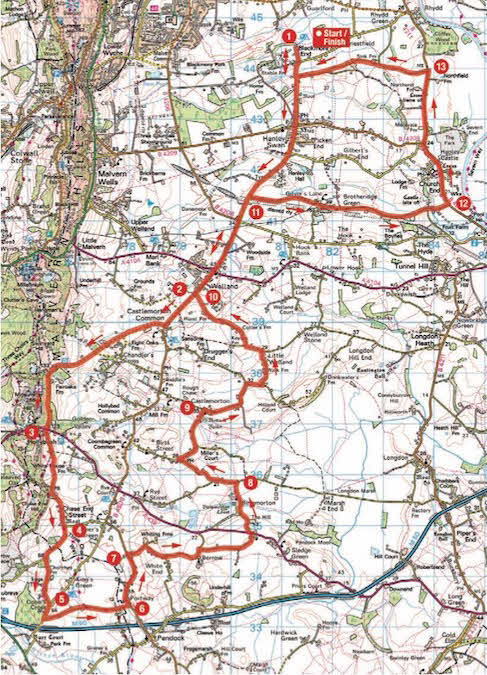
1. From Malvern Hills Club site ride to the end of the driveway, turn right and continue to Hanley Swan. At the crossroads, with the pond on the right, go straight over onto Welland Road. Continue on this road, which becomes the B4208, as it skirts Castlemorton Common. Just after the Castlemorton village sign, look for a turn on the right.
2. 6.4km – Turn right and follow the road as it crosses Castlemorton Common, heading towards the ridge of the Malvern Hills. Stay on this road for almost 4km, ignoring turnings, as it winds its way through the foothills of the Malverns, with lovely views left and right. Continue through woodland to reach a crossroads with the A438.
3. 10km – Go straight across the crossroads with the village hall on the left. After some more climbing the narrow road starts to descend, meeting a T-junction in 2km.
4. 12km – Turn right at the T-junction, signposted to Bromsberrow and Ledbury. Stay on this road for 850m until a sharp right bend, at which point turn left, following the ‘Byway Loop’ sign. Keep going to a T-junction by a triangle of grass.
5. 13.8km – Turn right at the T-junction, signposted to Redmarley D’Abitot, and in 250m turn left along Cook’s Lane, following the Byway Loop. Continue for 1.8km to a T-junction with the B4208.
6. 15.8kn – Turn left at the T-junction onto the B4208 and then turn right onto Whiting Hill Lane, signposted to Berrow Church. Stay on this road as it twists and turns for 1.7km, eventually becoming Church Lane. Shortly after a 90o bend to the left, look out for a road on the right.
7. 18.6km – Turn right along Chadds Lane signposted to Sledge Green and Tewkesbury. Continue to reach the A438, turn left and then immediately right, signposted to Birtsmorton Court & Church and Longdon. Continue to a T-junction.
8. 21km – Turn left at the T-junction, signposted to Birts Street and Castlemorton. In just over 1km, immediately after passing the Farmers Arms pub on the right, take a sharp right turn towards Castlemorton and Upton-upon-Severn. Continue to Castlemorton and a T-junction with a church on the right.
9. 23.5km – Turn right along Church Road. Stay on this road for 2.25km until a 90o bend to the right. Turn left here, signposted to Welland. Continue to a T-junction with the B4208.
10. 27.6km – Turn right at the junction, retracing a stretch of road from earlier in the route. Continue for 2.2km, eventually looking out for a turn on the right signposted to Gilvers Lane and Brotheridge Green.
11. 29.8km – Turn right here, along Gilver Lane, to reach a T-junction with the B4211.
12. 33.9km – Turn left, signposted to Hanley Castle. There is a cycle lane on the left to keep out of traffic. Ride through Hanley Castle (there is an attractive pub in the village, just past the school), and about 1.5km after leaving the village look out for a turn on the left along Hangman’s Lane.
13. 36.6km – Turn left along Hangman’s Lane and follow the road for almost 3km to reach a T-junction. Turn right and in 300m the turn to the Club site is on the left.
About the route
- Start/finish: Malvern Hills Club site, Blackmore End, Hanley Swan WR8 0EE.
- Distance: 25 miles/40km.
- Time: Two and a half hours.
- Level: Suitable for adult cyclists, due to brief spells on B roads.
- Terrain: Asphalt all the way, with a couple of modest climbs and quick descents. A road bike, hybrid or e-bike is ideal.
- Landscape: Grazing and arable farmland, broadleaf woodland and beautiful houses.
- Refreshments: Farmers Arms, Birtsmorton; Three Kings, Hanley Castle.
About the author