Itchen for a ride
Jonathan Manning revels in rolling downland on this pretty route
Explore the River Itchen valley and an ancient cattle droving route on this on- and off-road ride from Winchester Morn Hill Club Campsite.
There are pretty views and downland of farms and woods. Itchen Wood will be particularly beautiful in late spring when carpets of bluebells bloom below the beech trees.
The off-road sections, which follow the historic Ox Drove Way, are very well drained for the most part, so even in the aftermath of a named storm the track was easily passable and not too muddy.
The mill stream and river at Itchen Abbas offer attractive photo stops, as do the panoramas across the landscaped Avington estate.
In terms of off-road trail grades – which increase in difficulty from green to blue, red and black – this is no more than a blue at its most challenging and closer to green. So it’s a great way for mountain bikers of varying abilities to explore the Hampshire countryside.
Directions
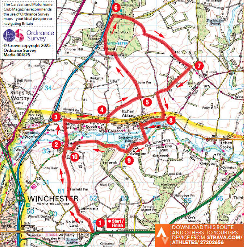
1. From the Club site turn right, pass Neptune Home, and at the T-junction turn right downhill along Chapel Lane. Continue for 3km to Easton and a T-junction opposite the Cricketers Inn.
2. 3.1km – Turn right at the T-junction and continue for about 1km to reach a T-junction with the B3047.
3. 4km – Turn right at the T-junction, signposted to Alresford and Itchen Abbas, and continue for 1.4km into Martyr Worthy, taking the third left, Chillandham Lane. Continue for 200m along the lane, passing under a bridge, to reach a drive on the right.
4. 5.6km – Turn right up the drive, which soon becomes a mud/grass bridleway to the right of a barn. Follow this to reach a unction of roads.
5. 6.8km – Turn left at the junction along an asphalt road and continue to reach a house. Leave the road and take the bridleway to the left of Oxdrove Farm. Continue for about 1.5km to reach a pair of gates (one ahead, one to the right) in a wood. Turn left and follow the trail to reach a vehicle track. Turn right on the muddy track, which soon becomes asphalt (with M3 immediately to the left). Continue to a T-junction.
6. 10km – Turn right at the T-junction and continue for about 650m to the end of the woods, then turn into a small car park on the right, where a waymark post indicates the Oxdrove Way and Watercress Trail. Follow the singletrack, which becomes a farm road. When the road starts to head downhill, take the waymarked track on the left, just before an open metal farm gate. Continue to a road.
7. 13.1km – Turn right along the road, and continue for 1.4km, taking the first road on the left (Rectory Lane) opposite a sign to Northington and East Stratton. Continue to reach a T-junction with the B3047.
8. 8 15.4km – Turn right at the junction, into Itchen Abbas, pass The Plough on the right, then take the first left, soon crossing a mill stream and river. Follow this road as it bends right through Avington to the end of the village.
9. 17.5km – Take the right turn to Easton and Winchester, passing through Avington Park. Stay on this road all the way into Easton, reaching a junction with the Cricketers Inn on the right.
10. 19.7km – Turn left opposite the Cricketers Inn, retracing the first section of the ride back to Winchester Morn Hill Club Campsite.
You can download this route from our dedicated Strava page here.
About the route
- Start/finish: Winchester Morn Hill Club Campsite, Alresford Road, Winchester SO21 1HL.
- Distance: 14.3miles / 22.8km.
- Time: 2 hours.
- Level: Some off-road experience advisable.
- Terrain: Quiet roads, field track and forest trails. Mountain or gravel bike required.
- Landscape: Rolling hills, farmland and woods.
- Refreshments: Cricketers Inn, Easton; The Plough, Itchen Abb
The Caravan and Motorhome Club make no warranties concerning the accuracy or completeness of the routes published, which to the best of our knowledge were correct at the time of publication. Your use of the routes is at your own risk and we accept no responsibility for the suitability or safety of any routes published. Routes may be out of date or affected by changes to the physical environment and, to the extent permitted by law, we accept no responsibility for personal injury or property damage caused by your use of the routes.
About the author